
Geo Fencing Meaning: How It Works & Key Uses
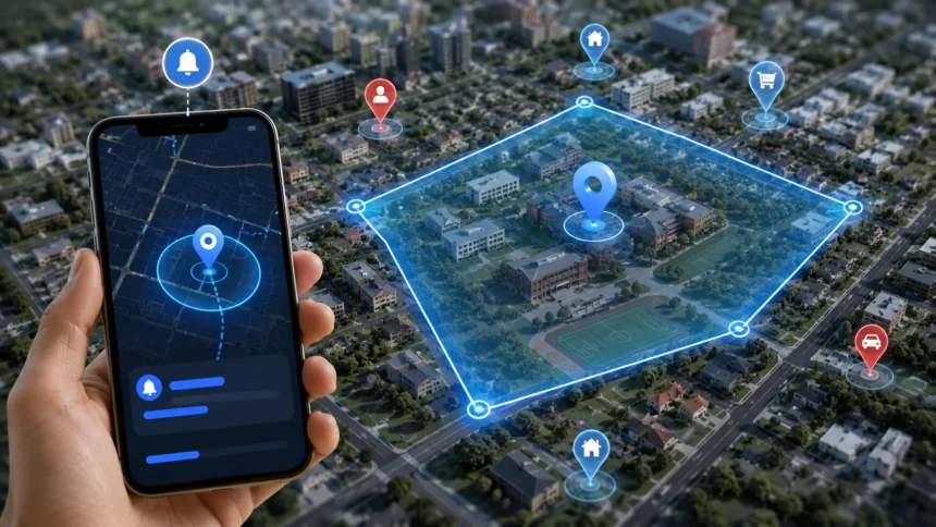
Geo fencing, more commonly written as geofencing, is a location-based technology that creates a virtual boundary around a real-world geographic area. When a smartphone, vehicle, wearable, or other trackable device enters, leaves, or remains inside that defined area, software can trigger a particular action. That action might be a mobile notification, security alert, employee check-in, smart-home command, fleet update, or marketing message. Unlike a physical fence, a geofence exists entirely in software and is usually defined using geographic coordinates, maps, and location services. Understanding geo fencing meaning is useful because the technology now appears in mobile apps, logistics, retail, transportation, security, workforce management, smart homes, and many other location-aware services.
A basic geofence might be a circular zone drawn around a store, office, school, warehouse, or home, although more sophisticated systems can use complex polygons that follow actual property or operational boundaries. Android’s current geofencing tools, for example, allow developers to define a geographic location using latitude, longitude, and a radius, then react when the device enters, exits, or dwells inside that area. Apple similarly describes geofencing as monitoring when a user enters or leaves a geographical region. This guide explains how geofencing works, its main types, key business uses, real-world examples, marketing applications, privacy considerations, accuracy limitations, and best practices for implementing it effectively.
What Does Geo Fencing Mean?
Geo fencing means creating a virtual geographic boundary around a real place and using software to detect when a device crosses or interacts with that boundary. The area can surround something as small as a retail store or as large as a city, depending on the technology and intended use. A geofence is typically connected to a location-aware device such as a smartphone, GPS tracker, vehicle telematics unit, or wearable. When the device’s reported position meets the rules associated with the boundary, the system can trigger an automated response. Esri describes a geofence as a virtual perimeter for a real-world geographic area that can be used to recognize when tracked objects approach, enter, or leave defined zones.
A simple example is a shopping app that has permission to use a customer’s location. The retailer can create a virtual zone around one of its stores and configure the app to react when the customer’s phone enters that zone. Instead of constantly sending promotions regardless of location, the business might show a relevant notification only when the person is close enough that visiting the store is practical. Google gives similar examples of customer engagement, where geofencing can trigger notifications about offers, events, or products when devices move through defined areas. The same underlying idea can support many non-marketing activities, including safety alerts, route monitoring, access control, and automated reminders.
The word itself becomes easier to understand when divided into two parts. Geo refers to geography or location, while fencing refers to defining a boundary that separates one area from another. Unlike a physical fence, however, a geofence does not stop someone from physically entering or leaving an area. Instead, it allows software to recognize that the boundary has been crossed and decide what should happen next. This distinction is important because geofencing is primarily an event-detection technology rather than a physical barrier. A company might receive an alert when a delivery truck enters a warehouse yard, but the geofence itself does not open the gate or physically control the truck unless it is connected with another system.
Geofences can also be temporary or permanent depending on the use case. A retail location might keep the same boundary active for years, while an event organizer could create a geofence around a stadium only during a specific concert or conference. A transportation company might create temporary zones around construction sites or weather hazards and remove them once the conditions change. Android’s geofencing framework even allows developers to specify an expiration duration so a geofence can be removed automatically when it is no longer needed. This flexibility allows geofencing systems to respond to both stable geographic locations and rapidly changing operational requirements.
The easiest definition to remember is that geofencing turns a real-world location into a software trigger. The boundary tells the system which geographic area matters, while the device’s location tells it whether the relevant condition has been met. What happens afterward depends completely on the application, which might notify a user, record an event, change a device setting, start a workflow, or alert another person. Because of this flexibility, geofencing is not one single product or app. It is a location-based capability that can be built into many different technologies and business processes.
How Does Geofencing Work?
Geofencing begins by defining an area of interest. In a simple mobile implementation, a developer specifies the latitude and longitude of the center point and then chooses a radius around it. Android’s documentation explains that these three values create a circular geofence around the selected location. More advanced mapping platforms can represent irregular boundaries using polygons instead of circles, which is useful for places such as industrial sites, delivery zones, neighborhoods, airports, campuses, or administrative areas. Once the boundary exists, the system needs location information from a device so it can determine whether that device is currently inside or outside the geofenced area.
The device’s position may be estimated using technologies such as GPS, Wi-Fi positioning, cellular information, Bluetooth beacons, and other sensors available on the device. Modern mobile operating systems often combine several signals because relying on GPS alone can consume more power and may perform poorly indoors or around tall buildings. The location system periodically updates its estimate and compares that position with active geofence boundaries. When the device changes from outside to inside, the system can generate an enter event. Moving from inside to outside can create an exit event, while remaining within the area for a specified period can create a dwell event.
Dwell events can be especially useful because devices sometimes briefly cross the edge of a geofence without the user actually visiting the location. Imagine someone driving past a shopping center whose geofence extends slightly into the road. An immediate entry notification could produce an irrelevant message even though the person never intended to stop. Android recommends using dwell transitions in some situations to reduce excessive alerts caused by brief entry and exit events. The system can wait until the device remains within the area for a defined period before deciding that the location is relevant enough to trigger an action.
After a transition occurs, another piece of software determines what action should follow. A mobile app might send a push notification, while a fleet platform records an arrival time and updates the expected delivery status. A home automation system could adjust lighting or temperature, and an industrial safety platform could notify supervisors when equipment enters a restricted zone. Google Maps Platform describes client-side geofencing as maintaining virtual boundaries and triggering software events when mobile devices cross those boundaries. The boundary detection itself is therefore only one stage; the real business value usually comes from the workflow connected to the resulting event.
Geofencing does not necessarily mean that an application must continuously run GPS at maximum accuracy every second. Mobile operating systems provide location frameworks designed to balance location awareness with battery consumption and privacy controls. On iOS, Core Location can monitor geographic conditions and notify an application when the relevant state changes, while Android exposes a GeofencingClient for similar tasks. The exact behavior depends on operating-system restrictions, permissions, connectivity, power settings, and device capabilities. Developers therefore need to design geofencing around the platform’s location services instead of assuming that every device can provide perfectly continuous real-time tracking.
Main Types of Geofencing
Circular geofencing is one of the simplest and most common approaches. The developer chooses a central latitude and longitude and defines a radius around that point, creating a virtual circle. This format works well for individual stores, offices, homes, restaurants, warehouses, parking areas, and other locations where an approximate distance from one point is sufficient. Android’s built-in geofencing implementation is based on circular regions defined using coordinates and radius values. Circular geofences are easy to configure and computationally efficient, but they may include nearby roads, buildings, or unrelated locations when the real property has an irregular shape.
Polygon geofencing creates boundaries using several geographic points connected together to form custom shapes. This is useful when the monitored area does not fit neatly inside a circle, such as a campus, airport, industrial facility, city district, delivery territory, or construction site. Google Maps Platform describes client-side implementations where applications maintain polygon boundaries and compare real-time device positions with those areas. GIS platforms can also use geographic map features as geofences, allowing boundaries to follow real-world administrative areas or complex operational zones. Polygon geofencing offers greater geographic precision but generally requires more sophisticated spatial logic than a simple radius.
Static geofences are tied to geographic areas that remain relatively stable. A retailer might maintain one around each store, while a company could define its office buildings and warehouses as permanent zones. These geofences may remain active until the organization deliberately changes or removes them. Static geofencing is useful for recurring workflows because the same location remains important every day. Employee arrival tracking, store-based notifications, and home automation are common examples where the underlying geography changes rarely. Maintenance is still necessary because businesses move, property layouts change, and location accuracy may reveal that an originally chosen boundary is too large or too small.
Dynamic geofences are created, modified, or removed according to changing circumstances. A delivery company could temporarily create a zone around a customer’s location while an order is active, or an emergency-management system might establish a geofence around an evacuation area during a wildfire. Fleet operators could use changing boundaries around construction zones, ports, temporary loading areas, or weather-related hazards. Because the geography changes, dynamic systems need current map data and reliable processes for updating rules quickly. They can deliver highly relevant location automation, but outdated temporary boundaries can create incorrect alerts if organizations fail to remove or revise them after circumstances change.
Another useful distinction is between device-side and server-side geofencing. Device-side geofencing relies on a phone or embedded system to determine whether it crossed the stored boundary, while server-side systems send location information to a backend platform that performs the geographic comparison centrally. Client-side approaches can reduce some server workload and respond locally, while server-side analysis can support large fleets, richer spatial data, and centralized operational oversight. Google Maps Platform’s current architecture guidance specifically discusses client-side polygon geofencing while recognizing business uses such as transportation, customer engagement, and security. Many large systems ultimately use a combination of local and cloud-based location processing.
Key Uses of Geofencing
Retail and marketing are among the most recognizable uses of geofencing. A retailer with a mobile app might create boundaries around stores and send customers useful information when they enter nearby areas, provided the necessary location permissions and communication preferences are in place. Messages could highlight store hours, pickup availability, loyalty benefits, or a relevant promotion rather than sending the same notification everywhere. Esri gives an example of a home-goods retailer using a geofence around a store to trigger information about a sale or a newly available product. Effective location marketing depends heavily on relevance because excessive or poorly timed notifications can quickly become annoying.
Transportation and logistics companies use geofencing to automate arrival, departure, and route events. A fleet-management platform can create virtual zones around warehouses, customer sites, ports, distribution centers, and service areas. When a truck enters one of these geofences, the system can automatically record its arrival rather than relying on a driver to manually update status. Exiting the zone can trigger another event showing that the vehicle has departed. Google specifically identifies vehicle tracking, route management, and transportation scheduling as geofencing use cases. This automation can improve visibility across large delivery networks and provide more accurate operational timestamps.
Security teams can use geofencing around sensitive or restricted areas. A business might define zones around warehouses, data centers, equipment yards, or high-risk operational areas and generate alerts when tracked assets or authorized devices move into or out of them. Google Maps Platform includes security and safety among current examples, including the ability to create virtual perimeters around sensitive locations and notify relevant personnel when boundaries are crossed. Geofencing should not replace physical access controls, cameras, identity verification, or other security measures. Instead, it provides another source of location-based information that can help organizations recognize events requiring attention.
Smart-home automation provides a consumer-focused example. A household could configure compatible systems to recognize when an authorized resident’s smartphone approaches or leaves home. Location events might be used to adjust heating, enable certain lighting routines, change notifications, or support other automation rules. Apple’s documentation gives location-based reminders as an example of region monitoring, where an application can react when someone arrives at or leaves a defined place. Smart-home geofencing needs careful setup because multiple residents, inaccurate location readings, dead phone batteries, and permission changes can produce unexpected automation if one phone is treated as the only signal determining whether anyone is home.
Workforce and field-service organizations can also use location boundaries for operational purposes. A field-service app might recognize that a technician has reached a customer’s site and offer relevant job information without requiring the technician to search manually. Construction companies can use geographic zones to improve awareness of where workers or equipment are operating, while organizations with distributed teams may use geofenced check-in features where legally and ethically appropriate. Esri identifies operations and public safety as industries where geofencing can support real-time situational awareness. Employers should be transparent about location collection and avoid turning operational tools into unnecessary surveillance.
Geofencing in Marketing and Customer Engagement
Geofencing marketing uses location boundaries to make customer communication more contextually relevant. Instead of targeting a person only because they belong to a demographic or interest category, a business can also consider whether the person’s device is near a useful location. A restaurant app might notify an opted-in customer about an available reward when they arrive near one of its locations, while an event application could display entry information when a ticket holder reaches the venue. Google gives an airline example where entering an airport geofence can trigger convenient access to a boarding-pass experience. These examples show that geofencing can support customer service as well as advertising.
The strongest geofencing campaigns usually provide immediate value. A message such as “Your pickup order is ready at this location” has a clear connection to where the customer is and what they are trying to do. By contrast, repeatedly sending generic advertisements simply because someone happens to pass through a wide geographic area may feel intrusive. Marketers should therefore think about intent, timing, frequency, and usefulness rather than treating every geofence crossing as permission to send another promotion. Dwell-based triggers can sometimes improve relevance by distinguishing people who remain in an area from those who only drive past it briefly. Android specifically recommends dwell events as one method for reducing alert spam.
Retailers can also use geofencing to improve physical and digital experiences together. A customer entering a shopping center could receive directions to a store, information about curbside pickup, or access to a loyalty feature designed for in-store use. Businesses can connect geofence events with customer relationship management systems or analytics platforms to understand how location-aware features are being used. However, organizations should avoid assuming that every detected visit means a customer purchased something or even intentionally visited the location. Location accuracy and overlapping neighboring businesses can create ambiguous results, so geofence events should be interpreted alongside other customer activity rather than treated as perfect evidence.
Competitor-area geofencing is sometimes discussed as a way of reaching customers near rival stores or related locations. From a technical perspective, a marketer can define areas around selected geographic points and use advertising platforms or app-based triggers according to the capabilities and rules of the chosen service. However, privacy rules, platform policies, consent requirements, and advertising restrictions can substantially affect what is permitted. Businesses should not assume that a technical ability automatically makes every targeting practice appropriate. Location data can reveal sensitive patterns about people’s lives, so marketing programs should minimize unnecessary collection and use transparent, lawful methods that match reasonable user expectations.
Measuring geofencing marketing also requires more than counting how many notifications were triggered. Useful metrics can include notification engagement, app activity, store visits when appropriately measured, completed pickups, redemptions, purchases, or other outcomes tied to the actual campaign objective. Marketers should compare these results with appropriate baselines so they can determine whether location targeting added value beyond ordinary messaging. Frequency limits are also important because high trigger volumes can increase app notification opt-outs or location-permission revocations. The most successful geofencing strategy is usually one that customers experience as convenient rather than one that constantly reminds them their location is being monitored.
Geofencing Accuracy, Privacy and Limitations
Geofencing is useful, but its boundaries should not be interpreted as perfectly precise physical lines. Smartphone location estimates vary according to GPS availability, Wi-Fi networks, cellular signals, buildings, terrain, sensor quality, and operating-system behavior. Android notes that when Wi-Fi-based location is unavailable, accuracy can degrade dramatically and may range from hundreds of meters to several kilometers in some circumstances. This is why extremely small geofences can produce unreliable results in environments where location accuracy is poor. Developers need to select boundaries based on realistic location performance rather than drawing the smallest possible circle simply because the mapping interface allows it.
Boundary behavior can also create false transitions. If a device’s estimated location repeatedly moves slightly inside and outside a geofence while the person remains physically near its edge, software may detect several apparent crossings. Large radii and dwell events can reduce some of these problems, although the best configuration depends on the use case. Android recommends considering a minimum radius around 100 meters for improved results in many mobile geofencing situations and using dwell transitions where brief crossings would generate unwanted notifications. A warehouse gate-control application may therefore require a different technical approach from a broad retail proximity notification.
Privacy is particularly important because geofencing depends on location information, which can be sensitive. Users should understand why an app needs location access, what benefits they receive, whether monitoring continues in the background, and how their information is handled. Android’s current documentation explicitly recommends explaining why geofencing requires background location so users can make an informed decision about permissions. Mobile operating systems also impose permission controls that can limit location access. A business should design its product so declining unnecessary location tracking does not result in misleading pressure or hidden data collection through alternative methods.
Platform limits and background restrictions also affect geofencing implementations. Android currently allows up to 100 active geofences per app per device user in its built-in geofencing system. Apple’s current Core Location condition monitoring limits each app to 20 monitored conditions at one time, meaning developers must prioritize which regions matter most. These restrictions do not make large-scale geofencing impossible, because applications can dynamically change monitored locations or perform some calculations on servers, but they influence system architecture. Developers should check current platform documentation rather than assuming limitations found in older tutorials still apply.
Geofencing also depends on the device participating correctly. A phone with location services disabled, insufficient permissions, aggressive battery restrictions, or no usable positioning information may not generate the expected event at the expected moment. Connectivity can further influence whether the triggered action reaches a remote server or whether a notification requiring online data can be displayed immediately. Therefore, critical safety systems should not rely on consumer smartphone geofencing as their only protection. Organizations should treat it as one useful signal within a broader system and design sensible fallback behavior when location events arrive late, fail to arrive, or contain uncertain coordinates.
How to Use Geofencing Effectively
The first step is defining the actual business outcome before drawing any boundaries. A retailer might want to help customers find pickup orders, while a logistics company wants accurate arrival timestamps and a security team wants warnings around restricted areas. Each objective requires different boundary size, event type, response speed, and accuracy. Starting with a map and creating dozens of geofences without a clear workflow often produces unnecessary alerts and complicated maintenance. Instead, teams should document what event matters, who or what is being monitored, what action should occur, and what should happen when location information is uncertain. Technology should support the workflow rather than become the workflow.
Choose geofence size according to location accuracy and real user behavior. A circular zone around a large shopping center may reasonably extend hundreds of meters, while a boundary intended to distinguish two neighboring storefronts may not work reliably with ordinary smartphone location alone. Android’s recommendations about wider radii and dwell events illustrate why developers should prioritize reliable experiences over artificially precise boundaries. Testing should include real movement such as walking, driving, entering buildings, and approaching from different directions. A geofence that works perfectly while a developer stands still outdoors may behave differently in underground parking, dense city streets, or rural areas.
Trigger only actions that remain useful in context. A customer passing near a store does not necessarily want a notification, and a truck entering a large industrial property may not yet have reached its unloading dock. Dwell time, working hours, customer preferences, current orders, route information, and recent notification history can all provide additional context before acting on a boundary crossing. Combining several signals often produces a better experience than responding mechanically to every enter event. Location automation should feel intelligent because the system understands the situation, not merely because it knows that one coordinate temporarily moved across an invisible line.
Design privacy into the system from the beginning. Request only the level of location access the feature genuinely requires, clearly explain the user benefit, and avoid retaining location history longer than necessary. Developers should also provide settings allowing users to understand or disable optional location-based features where appropriate. Businesses handling employee or customer location data should consider applicable privacy, employment, and data-protection requirements in the jurisdictions where the system operates. Android’s guidance specifically emphasizes transparency around background location access for geofencing. Trust is easier to preserve when people know how and why location information is being used.
Finally, monitor performance after deployment instead of assuming that geofencing is finished once the boundaries are created. Track missed events, false triggers, notification engagement, location-permission changes, battery complaints, and operational outcomes related to the feature. Store relocations, road changes, new buildings, revised delivery routes, and customer behavior can all make old boundaries less effective. Apple even provides developers with analytics reporting related to geofencing events and fence radii on supported platforms, illustrating how geofence behavior can be evaluated over time. Good geofencing is therefore an ongoing optimization process involving geography, software behavior, privacy, and real-world user experience.
Frequently Asked Questions About Geofencing
What is geofencing in simple words?
Geofencing means drawing a virtual boundary around a real-world location and using software to detect when a device enters, exits, or remains inside that area. The event can then trigger something such as a notification, alert, check-in, or automated workflow.
Does geofencing use GPS?
Geofencing can use GPS, but smartphones may also rely on Wi-Fi positioning, cellular information, and other device sensors to estimate location. The exact method depends on the operating system, device, environment, permissions, and required accuracy.
What is an example of geofencing?
A delivery company can place a virtual boundary around a warehouse and automatically record when a tracked truck enters or leaves the area. Retail apps can similarly use geofences to provide relevant location-based notifications when users have granted the necessary permissions.
Is geofencing accurate?
Geofencing can be sufficiently accurate for many applications, but it is not perfectly precise. Buildings, weak GPS signals, unavailable Wi-Fi positioning, device settings, and other factors can cause delayed or inaccurate location events.
Is geofencing the same as GPS tracking?
No. GPS tracking generally focuses on determining or recording the location of a device, while geofencing compares a device’s location with a defined geographic boundary and triggers an action when particular conditions are met. GPS or other positioning technologies can provide the location data that makes geofencing possible.